 Quick Facts:
The former name
of Banjul is Bathurst.
Named after Henry
Bathurst in 1816.
Renamed Banjul in 1973.
Prior to 1816 known as Banjulo.
Acquired
city status in 1965.
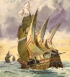 People have inhabited the area outside of Banjul island
for may millennia before the Portuguese navigators Antoniotti
Usodimare and Luiz de Cadamosto, entered the mouth of
the Gambia River in 1455 before being ejected by hostile
locals. They returned in 1456 and managed to reach James
Island further upstream.
People have inhabited the area outside of Banjul island
for may millennia before the Portuguese navigators Antoniotti
Usodimare and Luiz de Cadamosto, entered the mouth of
the Gambia River in 1455 before being ejected by hostile
locals. They returned in 1456 and managed to reach James
Island further upstream.
 After
the abolition of the slave trade in 1807 the British
had to find an alternative to James Island, which was
situated on the river, to better control access to the
river and enforce the Slavery Abolition Act. The first
reason was because the Americans, Portuguese,
Spanish and French continued to trade in slaves. Secondly
to protect British commercial interest in the interior
of the region. After
the abolition of the slave trade in 1807 the British
had to find an alternative to James Island, which was
situated on the river, to better control access to the
river and enforce the Slavery Abolition Act. The first
reason was because the Americans, Portuguese,
Spanish and French continued to trade in slaves. Secondly
to protect British commercial interest in the interior
of the region.
In 1815 Sir Charles MacCarthy (Governor-in-Chief of
all the British settlements on West Africa) gave an
order to Alexander Grant, a British officer, to sail
down from the Senegalese island of Gorée with a 75 strong
detachment from the Royal African Corps, to look into
the possibility of establishing a military stronghold
in Gambia. After a tour and inspection of James Island
they settled for St. Mary's Island (then known as 'Banjulo'
by the Portuguese).
On the 23rd April 1816 Captain Alexander Grant entered
into a treaty with Tomani Bojang, the (Mansa) 'King'
of Kombo, for the leasing of the island which was duly
leased by the British Government for a yearly payment
of 103 iron bars, which was the equivalent of £25 at
that time. The island was re-named St. Mary's Island
(after Cape Point's St. Mary area) and a settlement
was established named Bathurst, after the then Secretary
of State for the British Colonies, Henry Bathurst.
Grant proceeded to construct an army barracks barracks
which could hold 80 soldiers & house six cannons
to guard the entrance to the Gambia River. Their task
however, was made extremely difficult as Bathurst was
essentially a flat land mass which was mosquito infested
and susceptible to regular flooding. By 1821 a number
of official buildings were finished which included
the Barracks, a hospital, and a court house among others.
That same year Bathurst was put on a more formal footing
when it was incorporated and administered under the
authority of the Governor of Sierra Leone. In 1843 The
Gambia became a colony with its own Governor, judicial
system, executive and legislative councils. However,
in 1866 the settlement was once again bought under the
authority of the Governor of Sierra Leone and it was
not until 1888 that it reverted back to a colony in
its own right.
The British Government's policy was that apart from
the cost of defence all other costs of maintaining the
colony had to be derived from customs duties on imports.
In 1822 Sir Charles MacCarthy, after his tour of the
West Africa, commented about the improvement in commerce
of Bathurst being greater than any of the other posts
occupied by her Majesty's forces on the coast.
 After
3 months and a lot of effort by Grant's men and having
endured high death rates from malaria and other swamp
fevers the island soon became secure enough for it to
be used as a trading stronghold which allowed British
traders to transfer their base from Gorée Island
to Bathurst. Some of these merchants were the descendants
of earlier inter-marriages between British colonists
and locals on Goree who were known as the senioras who
were Mulatto. These last people eventually owned large
estates particularly country homes in the Kombos. After
3 months and a lot of effort by Grant's men and having
endured high death rates from malaria and other swamp
fevers the island soon became secure enough for it to
be used as a trading stronghold which allowed British
traders to transfer their base from Gorée Island
to Bathurst. Some of these merchants were the descendants
of earlier inter-marriages between British colonists
and locals on Goree who were known as the senioras who
were Mulatto. These last people eventually owned large
estates particularly country homes in the Kombos.

MacCarthy Square (July 22nd Sq.), was named after Brigadier
Sir Charles MacCarthy (governor of Sierra Leone and
the West African Settlements). It was at the very centre
of the cluster of Government buildings. The first public
buildings encircled the square. They were the Government
House and a six gun battery, barracks, officers
mess [now the Government offices in the Quadrangle],
and the Colonial Engineers Yard, which later became
Albert Market.
In 1818 the total population of the new settlement was
around 600. By 1826 this figure had risen to 1,800 (excluding
the garrison) of which 30 were Europeans. In the 1830s
ship loads of liberated African refugees landed in Bathurst
and were transported to the Liberated African Yard.
Goderich Village was created near Oyster Creek by the
Colonial Government in 1832 to specifically assist these
Liberated Africans. By the middle of the 19th
century the local population of Bathurst was 4,000 as
well as 190 colonialists.
This growth in the numbers of people was caused by an
influx of freed slaves from Freetown, fugitives evading
justice and people from the Wolof tribe of Gorée Island
& St. Louis in Senegal. Such was the uncontrolled
migrations that Lieutenant Governor Mackie tried to
put a stop to it. His job was made difficult by the
religious wars raging in the region. Over time people
from other tribes of West Africa also joined them enabling
Bathurst to grow from a fort with a few outlying local
villages into a city within 100 years. The reason for
this growth was because the deep port allowed large
ships to dock and thus propelled Bathurst into one of
West Africa's main trading gateways, particularly entrepot
trade, to other West African countries.
The settlement's local divisions was reflected by the
various people who had come to live there. Bathurst
was planned and divided into districts for specific
ethnic groups. There was Soldier Town where the pensioners
from the West Indian Regiments and Royal Africa Corps
resided. There was Jolof Town, which was largely made
up of artisans and mechanics from the people of the
Wollof ethnic group. There was the poorest sector known
as Moka or Mocam Town, which was later re-named Half-Die
after the Cholera epidemic of 1869 killed many there,
was populated by immigrant labourers from the Kombos
and up-river areas. There was also Melville Town occupied
by the Akus which had earlier been settled by the Jolas.
And finally there was Portuguese Town which was occupied
by the Mulatto descendants of mixed African and Portuguese
parentage. As the settlement grew street names were
given which were from either prominent merchants or
generals who served in the Battle of Waterloo. In recognition
of his efforts to stop the slave trade along the river
a street was named after him called Grant Street.
The settlement was declared capital of the newly established
"Crown Colony and Protectorate of The Gambia"
in 1889.
The port town gained the status of a city in 1965
which was the same year The Gambia became independent.
In 1973 Bathurst was re-named Banjul.
After a period of stagnation and decay in the 1980's
the capital saw a rapid exodus of much of the population
from Banjul and out into the Kombos creating the Greater
Banjul area. Presently old and decaying residential
homes and commercial buildings are being demolished
and are being largely replaced by new commercial warehouses
and residential apartments.
 |